Maps Show Locations and Areas
Systematic Grids
We start this unit talking about how maps show locations using systems and grids.
The primary function of maps is to show where things are. To learn how maps show this, it is first necessary to understand how everything gets positioned on a map. Geographers have created a systematic way to locate points on the Earth. Each location is assigned a pair of coordinates which define its position. The following discussion of the basics of that coordinate system should be review, but of course that depends on how long ago you were taught them.
Think in terms of conventional coordinate systems, also known as "graticules."
Latitude and longitude correspond to "y" and "x," respectively, in a conventional "plane geometry" coordinate system. Plane geometry is the first geometry we are taught because every shape and measurement occurs on a flat plane. Important concepts included:
- the point, and its (x,y) coordinates
- the straight line, and the ability to measure its length
- shapes such as rectangles, triangles and circles
- the ability to measure the area of a shape
- the ability to measure a distance between two points using the Pythagorean theorem
We will use all of those concepts in the study of maps, but we will have to move beyond plane geometry.
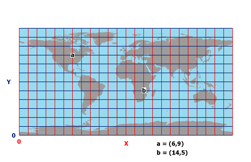
The first illustration below presents a coordinate system as used in plane geometry. Simpler versions of the coordinate system label the lower left corner with the coordinates (0,0).
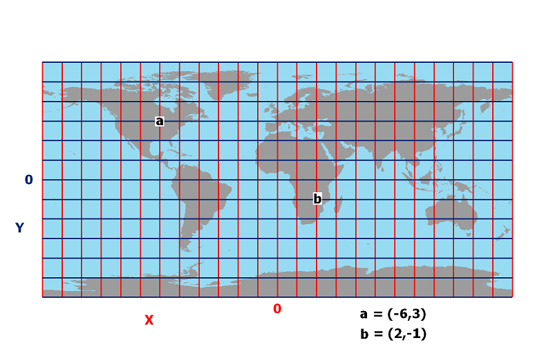
As you learned more about plane geometry, you came to understand that (0,0) could be anywhere on the grid, as shown in the second illustration, and that any location to the left of x=0 would have a negative x-coordinate, while any location lower than y=0 would have a negative y-coordinate.
Maps Also Show Areas
The areas mapped are made up of larger areas divided into smaller areas.
Understanding the information displayed in maps also requires that we understand this organizational structure. This model of geographical, or spatial, organization is done by several different groups for very different reasons. The key concept here is boundaries.
The organizations named in the list below have different political, economic or other reasons for subdividing the land. In some cases the implications are very great, affecting whom we can vote for, whom we pay taxes to, and what public schools our children must attend. In other cases the implications are very minor, such as the boundaries between different newspaper delivery routes.
Here are a few of the more significant ones:
- Governmental Organization: You live in a State (or similar territory, such as DC or Puerto Rico), which is divided into counties (or, in Louisiana, parishes). In most states the counties are divided into smaller municipalities; in Pennsylvania, for example, your county contains many townships, boroughs and cities. Most of those Pennsylvania cities and boroughs are further subdivided into Wards, while other states may have different organizational structures and names.
- Survey Systems: Your state and local governments are responsible for keeping track of property ownership. In many cases, properties have changed hands and have been subdivided so many times (historically speaking) that this is a monumental task. In other cases, there is a larger overriding survey system whose integrity must be maintained.
- School Districts: In many states the school system is managed by entities of the governmental structure such as counties. In others, including Pennsylvania, school districts have formed which exist outside of the local governmental structure. Going up the ladder, the school districts are organized into Intermediate Units for some regional coordination and cost saving. In the other direction, school districts are divided into service areas for each level of education, and for each individual school.
- Other Social Organizations: Many of our social services are run by government agencies at different levels of government. Many other services are provided by non-profit or public service organizations. Examples include the Post Office, churches, Scouts, the American Automobile Association, and many others whose national headquarters have decided to organize geographically for greater efficiency.
The Importance of Maps to these Organizations
One of the implications of these varied bases for spatial organization is that when the organizations named above want to display information about their constituents, they often use maps to accomplish it. All of the public and private organizations described on the last two pages use geographers, or people with related skills, to produce their maps.
The geographical work involved in the map production goes beyond cartography. It involves working with field crews, aerial photography, questionnaire surveys and other clues about what will make functional sense for that organization.
Imagine, briefly, one example. School Districts require information on every student attending their schools, including home address, some family income information, age and grade, and others. They then need to partition the elementary age children into the elementary schools by choosing appropriate boundaries. They must be intimately familiar with the roads throughout the district in order to know which ones are suitable (or not) for school buses, and where are appropriate bus stop locations.
This example raises another issue, of course. What if the school district (or other organization) does not have people with the necessary skills? There have been plenty of examples, over the years, of organizations who were out of touch with their clients or their territory's "geography."
The best way of checking whether organizations are doing a good job of analyzing the map information they have to work with, is to check the quality of the maps they produce.
Almost all of the organizations mentioned in these pages are not only map publishers, but are also publishers of the data that go into producing and analyzing their maps, which is a key GIS consideration.
The Latitude-Longitude Grid
Euclidean vs Non-Euclidean Geometry
The Earth requires a non-Euclidean coordinate system, better known as the Latitude-Longitude Grid.
Euclid was an early Greek mathematician who is recognized as the founder of geometry because he organized and established rules about many of the simplest geometric shapes. The geometry he developed is now referred to as plane geometry: the geometry of flat, or plane, surfaces, which was described above.
Latitude and longitude are the components of a coordinate system on a round surface, very different from a flat plane. Each of the plane (or Euclidean) geometry concepts mentioned above has its non-Euclidean counterpart:
- the point, and its longitude-latitude coordinates
- the straight line (a line on the surface that does not bend left or right), and the ability to measure its length
- shapes such as rectangles, triangles and circles (defined by their edges, even though they are no longer flat)
- the ability to measure the area of a shape (we won't do this in this course, except using plane geometry techniques on flat maps)
- measuring a distance between two points (again, in this course we will only do this using techniques developed for plane geometry on flat maps)
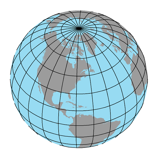
The diagram below illustrates a coordinate system as used in non-Euclidean geometry. Note the aspects of it that correspond to elements of plane geometry coordinates: the "0" coordinate for latitude is the equator, and the "0" for longitude is the prime meridian. Instead of negative and postive latitudes, we read south and north; instead of negative and positive longitudes, we read west and east.
The goal in this course is not to make you an expert in non-Euclidean geometry, but to help you to recognize when the difference between plane geometry and non-Euclidean geometry is relevant.
Latitude
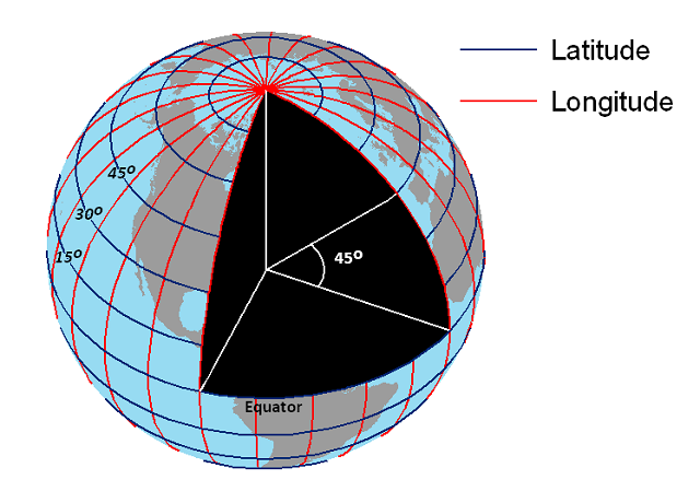
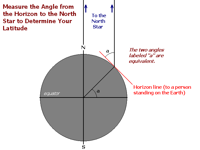
Latitude is an angle measurement, the angle from the equator (directly south or north of the point of interest) to the exact center of the Earth, and back out to the point of interest. The center of the Earth is the intersection of the axis with the plane of the equator, so it serves a geometric purpose as well as having a geological significance. This illustration below shows such an angle, which would describe a line of latitude north of Pennsylvania (after Encyclopaedia Britannica).
Measuring Latitude
Measuring latitude (without a GPS unit) required mariners to use a device known as a sextant (there were other variations on this design). It was basically a finely constructed protractor with a telescopic viewing lens to help the navigator find both the North Star and the horizon (see the diagram below) in order to measure the angle between them.
The same principle, and device, can be used to measure the angle from the horizon to the sun, but it would be necessary to account for angle changes due to the date of the year. The angle of the Earth's axis compared to the sun's position is constantly changing, but the alignment of the Earth's axis with Polaris, the North Star, does not change.
Longitude
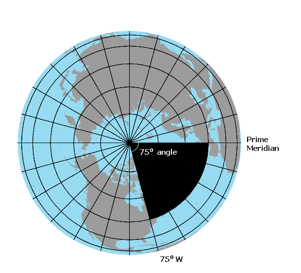
Longitude is also an angle measurement, the angle from the prime meridian (directly east or west of the point of interest) to the Earth's axis, and back out to the point of interest. When we adopt a perspective over the North Pole, the geometric function of the Earth's axis becomes clearer (after Encyclopaedia Britannica).
The Prime Meridian
Unlike the Earth's axis and equator, two lines that have a natural purpose and function, the prime meridian is completely arbitrary. The current Prime Meridian, recognized worldwide, is a meridian that travels through the location of a particular observatory in Greenwich, England (Male, 2005-8a). In fact, before the late 1800s (and well into the 1900s for some countries) most countries had their own prime meridians. The United States's prime meridian went through Washington, DC (Wikipedia contributors "Washington meridians"). In 1884, at an international conference held in Washington, DC ironically enough, the world's great seapowers agreed that England's prime meridian should become the international standard (Male, 2005-8a).

Measuring Longitude
Measuring longitude in the days before long-distance communication and other modern technologies required mariners to use a specially-designed clock. The clock was able to keep accurate time after weeks or months in the rough seas, in the salty air, and in the temperature extremes of an ocean-crossing voyage. The clock has to be kept wound, so that it never skips a second, and its time is never changed from the time it is at the prime meridian.
The principle behind the use of the clock is that, because the Earth rotates once (an entire 360° of longitude) every 24 hours, there is a definitive relationship between longitude and time. Not only is 1 hour of time equal to 15 minutes of longitude (to be discussed further soon), but a similar relationship can be defined for one minute of time and one second of time. The traveller has to determine exactly when the sun is directly overhead; that would determine solar noon for his location. As soon as it is solar noon, he looks at the clock. The time difference between solar noon at the traveller's current location and the time (according to the clock) at the Prime Meridian allows him to calculate his exact longitude.
Decimal Degrees
The graticule, as it is referred to technically, is the most universal of the options listed on the previous page. It is a global system, and yet a location reported to the nearest second of latitude and longitude is within 100 feet of the object. Latitude and longitude locations are often reported to the nearest tenth or hundredth of a second, which makes them very precise indeed.
Still, the principal limitation of this oldest of global location systems is the awkwardness of dealing with minutes defined as sixtieths of a degree, and seconds defined as sixtieths of a minute. This was especially problematic for the military, and also for the development of computer-based mapping, as neither the military user nor the computer programmer is used to working in such a number system. The solution evident in most computer applications is the conversion of "degrees, minutes and seconds" to "decimal degrees." In the latter version of the graticule the "minutes and seconds" fraction of a degree are reported as the decimal places in a decimal number. For a simple example, in the latitude location 24 degrees, 15 minutes and 0 seconds (also written as 24° 15' 0"), it is recognised that 15 minutes is a quarter of a degree, so the location becomes 24.25°.
Time and Longitude
Time, Especially Noon
Solar Noon
Keep in mind that time worked as the first measure of longitude because the set of longitude angles relative to the Prime Meridian can be shown to correspond to unique times on a 24-hour clock. The Earth is covered by 360° of longitude, and rotates once every 24 hours.
Another way to think of this connection between time and longitude is that the point in time every day when the sun is at its highest in the sky where you are standing is the point in time when your meridian is closer to the sun than all other meridians. Every meridian enjoys this brief uniqueness once every 24 hours. The link below goes into a little more depth (Wikipedia contributors). A more visual way to describe this point in time is to insert a stick vertically into the ground at your location on a sunny day and watch carefully for the point in time when that stick's shadow is shortest.
This point in time is, technically, noon. It is referred to as solar noon because it is determined by that unique Earth-Sun relationship. You could set your watch by solar noon, as long as you spend every day at the same exact location. The problem with using solar noon as a reference for telling time, though, is that (solar) noon arrives at the east end of your community a little earlier than it arrives at the west end of your community.
Local Noon
In the days before long distance communication technologies, and even in the days before rapid transportation such as by railroad, this problem of "What time is it in our community?" was resolved by each town establishing a common time reference. For this purpose they erected a building with a tall clock tower in the center of town, so that the clocks on that tower would be visible to most of the town's residents. Solar noon was thus replaced by local noon.
But, even that proved to be problematic because, when the railroads and telegraph systems did come, every train stop or message forwarding stop along a long-distance journey meant changing the time of arrival and departure. Imagine making a 300-mile journey west through 15 towns and wanting to get off the train and stretch your legs at each stop. You would have to reset your watch in each town to its local clock so that you knew what time to get back on the train before it left.
Time Zones
The Purpose of Time Zones
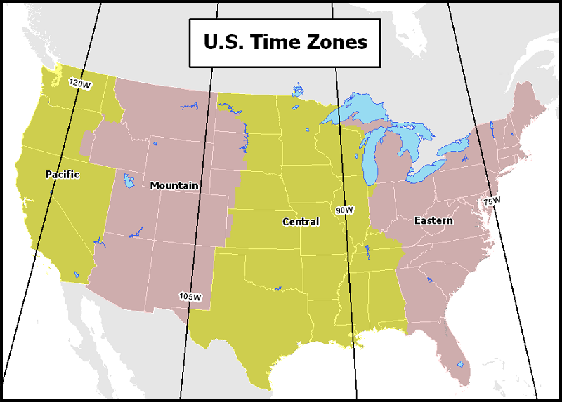
Time zones were established to reduce the problems caused by too many local time references. Since the Earth rotates 360° in 24 hours, it rotates 15° every hour. The concept was simple enough: establish the same time reference for every place within a 15° span of longitude, and have the time reference jump by a whole hour when you pass into the next 15° zone. The time would get an hour earlier at each time zone crossing as you travel westward, and would get an hour later as you crossed a time zone traveling eastward.
In actuality, using a particular meridian as the boundary between time zones often proved to be a problem because that meridian could split a community in two. A map of the time zones of the US shows the compromises they were forced to reach in order to keep communities and regions in the same time zone.
Discussion of these concepts will be continued in the context of map scales and distance measurements later in this course.
The International Date Line
The International Date Line is, nominally, the meridian that is opposite the Prime Meridian. Where the Prime Meridian is 0° (neither East nor West), the International Date Line is 180° both East and West). But the significance of the International Date Line goes way beyond assigning a name to the "last" meridian. It actually does have date significance, as anyone who has crossed the line while travelling can attest. This video clip will illustrate why the International Date Line is so named.
Jules Verne's Around the World in Eighty Days is a great illustration of the International Date Line
The International Date Line played a key role in the classic novel by Jules Verne, "Around the World in 80 Days." The entire story line hinges on the International Date Line's existence, and the characters' ignorance of it. The basic story line is as follows:
The main character is Phileas Fogg, an Englishman in the 19th Century who is wealthy enough that he doesn't have to work and can spend days at his "club." He makes a bet with other club members that he can complete a journey around the world in 80 days, based on his investigations of ship and railroad timetables of English colonies and other countries. Other club members take him up on his bet and he leaves that evening with his new servant, Passepartout, on the trip. Unfortunately, a bank robbery has taken place on that same day, and Fogg fits the robber's description, so Scotland Yard's Detective Fix is also in pursuit.
The story centers around Fogg's successes and failures at keeping to his schedule. Some of the delays involve great adventures and others are engineered by the Detective trying to delay the travelers until he can be sent an official arrest warrant. They continue to elude the detective, even while picking up a third traveller in India. The trip continues through southeast Asia, Japan and across the Pacific to San Francisco. Verne was French, of course, and his tales about the group's journey across America are naive, though probably consistent with what other Europeans were hearing about America at the time.
Throughout the trip Passepartout has been keeping a count of the days. When their departure from New York on the final leg of their journey is delayed, they (including Detective Fix) are forced to take passage on a small steamship heading for France. It is an eventful trip that includes a mutiny, running out of fuel, Fogg's purchase of the ship from its captain, tearing up parts of the ship to burn for fuel, and redirecting the ship to Liverpool, England.
They arrive in England on the 80th day of their journey, but are arrested by Detective Fix as soon as they set foot on English soil. They spend the night in jail before Fix learns that the actual robber had already been caught. Fogg and company return to London on their 81st day of travel, but during the course of the day they learn that it is not Sunday, but Saturday. They make it back to Fogg's club just in time for Fogg to win the bet and to claim his prize. [Note: a more thorough synopsis is available from Wikipedia (Wikipedia Contributors), or you could read the book itself, which has been published in many editions.]
Of course, the reason for their miscalculation of the date was their crossing of the International Date Line from the eastern hemisphere to the western hemisphere, in addition to not noticing any other potential clues in their journey across America and the Atlantic.